critical element in the planning process. Knowledge regarding such resources is important to their protection and conservation. These natural systems provide the means for "... waste disposal, pure water, minerals, food...as well as recreation..." (Wharton, p. 8) Awareness of the resources supporting natural systems allows future development to coexist with critical natural systems in a way which ensures the viability of resources in the county in years to come.
It is important to consider the topography and slope of an area when planning development since these are crucial factors in determining the suitability of certain areas for development. Man-made additions to the environment can cause damage such as increased stormwater runoff and soil erosion, if not sited properly. Certain areas may be subject to flooding, while others may be too steep to be safely built upon.
Hart County is located in the Midland Georgia Subsection of the Southern Piedmont Section of
Georgia. The Southern Piedmont is located within the Piedmont Province of the state. The terrain is characterized as gently rolling topography ranging from 1000 feet to 500 feet. Stream valleys are generally deep and narrow and have narrow, rounded stream divides.
The county is bounded to the north and the east by Lake Hartwell which covers approximately 17,000
acres of land area in Hart County. The Tugaloo and Savannah Rivers which are a part of Lake Hartwell form the eastern boundary of the county and state. No major rivers pass through the county, although there are numerous small streams in the area. Shoal Creek and Little Shoal Creek bisect the northwestern portion of the county.
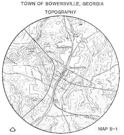
Beaverdam and Pruitt Creeks are prominent in the southwestern portion of the county. Little Coldwater and Boyd's Creeks run in an easterly direction from a point south of U.S. 29, approximately four miles below Hartwell, into Elbert County. Slightly to the north, Cedar Creek flows easterly into the Savannah River. Relief in the Hart County area is generally comprised of large mildly rolling expanses. Elevations range from 700 feet above sea level near Lake Hartwell to 900 feet in the western portion of the county. Steep slopes border the streams in the northwestern and northeastern parts of the county. By and large, however, slopes do not pose substantial limitations on development in Hart County. Elevations in Bowersville range from 840 to 900 feet above sea level and slopes do not present limitations upon development. Map 5-1 presents the topography in Bowersville.
Geologic formations in Hart County include several types of igneous and metamorphic rocks. A large portion of the northern section of the county , as well as an area in southwestern Hart County are composed of intermediate gneiss type formations. Sections of undifferentiated granite are located in the central portion of the county. The majority of the county, however, is underlain with aluminous schist type rocks. Geological processes have resulted in a fault line in the southeast corner of the county.
A variety of minerals are found in the county, including mica and sillimanite. Mica is located in the middle portion of Hart County, and is also indicated in several spots north of Hartwell, near the lake. It is actively mined in Hart County and used for pigments and fillers. Patches of sillimanite are found in central and southern Hart County.
It is also indicated in dispersed locations throughout the county including the vicinities of Vanna and Bowersville, as well as north of Hartwell near the lake. Other minerals include large sections of granite, scattered locations of gold, and iron.
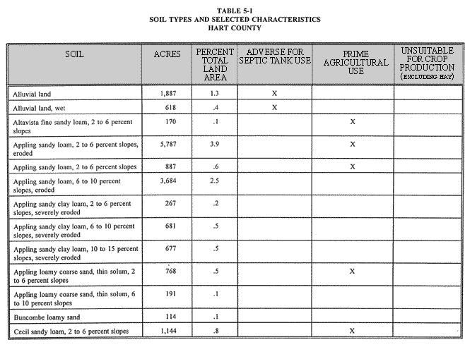
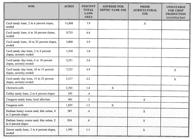
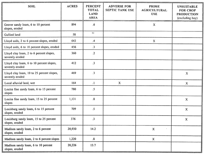
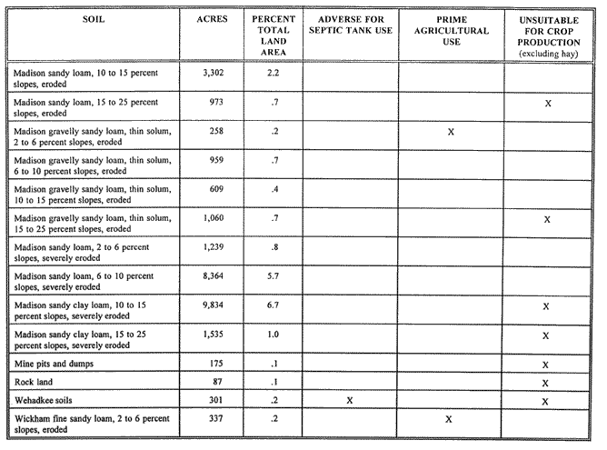
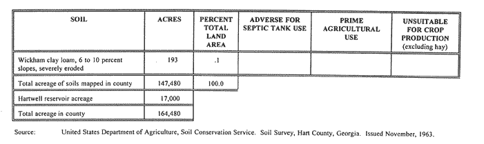
A variety of soils are found in Hart County. The most common soil type (Madison sandy loam, 2-10%
slopes), which comprises 27.9% of all soils in the county, is suitable for septic tank use as well as for crop production. Table 5-1 indicates the soil types found in Hart County as well as their suitability for certain uses.
In the Comprehensive Plan, the purpose of soils analysis is to identify those soils which indicate where various types of activity should or should not occur. Certain soils have outstanding capacity for agricultural uses, while others may be unsuitable for crop production. In addition, other soil types can not be used for adequate disposal of sewage. Since over 95% of soils in the county are suitable for septic tank use, soils pose few restrictions on residential development using septic tanks.
Approximately 75% of land in the county is suitable for various types of crop production, excluding hay.
In the soil survey for Hart County, soils are classified based upon general suitabilities for farming. For purposes of this plan, soils rated as a Class I or Class II are categorized as the prime agricultural soils in Table 5-1.
Class I soils have few limitations that restrict their use. Class II soils generally have moderate limitations
that reduce the choice of plants or that require moderate conservation practices. Together, Class I and II soils comprise 48,123 acres or 33% of all soils countywide. Soils in Bowersville have few limitations. Soils along streams in the city are unsuitable for septic tank use. Any proposed site should be carefully studied to determine that the soil can support the intended structure.
Since few if any significant development limitations are posed by the soil characteristics in Hart County and Bowersville, no special measures are called for in this plan to address protection and conservation of soils.
HART COUNTY SOIL ACRES PERCENT TOTAL LAND AREA ADVERSE FOR SEPTIC TANK USE PRIME AGRICULTURALUSE UNSUITABLE FOR CROP PRODUCTION (excluding hay)
Source:United States Department of Agriculture, Soil Conservation Service. Soil Survey, Hart County, Georgia. Issued November, 1963.
Studies by the Soil Conservation Service have identified areas of prime farmland as well as additional
farmland of statewide importance. "Prime farmland" is defined as ...land best suited for producing food, feed, forage, fiber, and oilseed crops, and also available for these uses. It has the soil quality, growing season, and moisture supply needed to produce sustained good yields of crops economically if treated and managed, including water management, according to modern farming methods.
"Additional farmland of statewide importance" is defined as land...that is important for the production of food, feed, fiver, forage, and oilseed crops. It economically produces good yields if the soils are drained or are drained and protected against flooding, if erosion control practices are installed, or if additional water is applied to overcome droughtiness.
According to a generalized statewide map, prime farmland and additional farmland of statewide importance comprise approximately 50% to 100% of the land in Hart County. The remaining areas which have characteristics limiting usage as prime farmland, primarily a high seasonal water table, are located in the northern portion of the county. As mentioned previously the local soil survey indicates that the prime agricultural soils comprise over one-third of the soils (and land area) in Hart County.
Prime agricultural lands should be preserved to the greatest extent possible. The urban growth boundary concept, as discussed elsewhere in this Comprehensive Plan, if implemented, will help protect such lands from scattered residential development, the most likely threat. The vast majority of development would be concentrated, thus preserving agricultural lands.
It was noted in the economic development element the nature and extent of commercial forest lands in Hart County. No special measures are called for in this plan to preserve prime forest lands.
Wetlands are those areas that are inundated or saturated by surface or groundwater at a frequency and duration sufficient to support, and that under normal circumstances do support, a prevalence of vegetation typically adapted for life in saturated soil conditions. Wetlands generally include swamps, marshes, bogs and similar areas. The ecological parameters for designating wetlands include hydric soils, hydrophytic vegetation and hydrological conditions that involve a temporary or permanent source of water to cause soil saturation. Fresh water wetlands and aquatic habitats are classified by the Georgia Department of Natural Resources into the following categories:
• Open Water - Areas of open water, primarily reservoirs, ponds, lakes, rivers, and estuaries.
• Non-Forested Emergent Wetlands - freshwater marshes dominated by a variety of grasses, sedges, rushes, and broad leaved aquatics associated with streams, ponded areas, and tidally-influenced non-saline waters.
• Scrub/Shrub Wetlands - non-forested areas dominated by woody shrubs, seedlings, and saplings averaging less than 20 feet in height; these wetlands may intergrade with forested wetlands, non-forested emergent wetlands, and open water.
• Forested Wetlands - natural or planted forested areas having a dominant tree crown closure or hardwoods, pines, gums, cypress, or any combination of these types. These areas are usually in stream or river floodplains, isolated depressions, and drainways, and contain standing or flowing water for a portion of the year.
Subcategories:
• Hardwood floodplain forests
• Coniferous floodplain forests
• Mixed floodplain forests
• Non-alluvial forested wetlands
• Altered Wetlands - areas with hydric soils that have been denuded of natural vegetation and put to other uses, such as pastures, row crops, etc., but that otherwise retain certain wetland functions and values.
Table 5-2 indicates important values that wetlands provide, while Table 5-3 provides typical vegetation found in different types of wetlands.
| SOCIOECONOMIC VALUES |
ENVIRONMENTAL QUALITY VALUES |
|
|
| FISH AND WILDLIFE VALUES |
|
| • Fish & Shellfish Habitat • Waterfowl & Other Bird Habitat • Forbearer & Other Wildlife Habitats
|
|
Source:American Planning Association, Planning Advisory Service. 1988. Protection of Non-Tidal Wetlands. (Report Number 412/413).
Emergent Wetlands:Freshwater Cattails, wild rice, sedges, rushes, bulrushes, spikerushes, burreeds, rice cutgrass, maidencane, reed, arrowheads, pickerelweed, smartweeds, bluejoint, whitetop, reed, canary grass, manna grass, asters, goldenrods, marsh fern,
Pocosins
Pond pine, sweet bay, inkberry, fetterbush, titi,
red bay, wax myrtle
Others
Buttonbush, alders, willows, dogwoods, red maple
sapplings, cottonwood saplings
Source:American Planning Association, Planning Advisory Services. 1988.
Protection of Non-Tidal Wetlands. (Report Number 412/413).
The probable existence of wetlands can be identified by the existence of hydric soils, as well as by analysis of land cover data available from the Georgia Department of Natural Resources. Table 5-4 lists the hydric soils found in Hart County.
| MAP SYMBOL |
SOIL NAME |
COMMON LOCATION(S) |
| AVP |
Alluvial land, wet |
Along small streams |
| CFS |
Chewacla soils |
Pastures, mixed hardwoods
|
| LCN |
Local alluvial land, wet |
Base of slopes, low areas at head of intermittent drainageways
|
ource:USDA. Soil Survey Hart County, Georgia, 1963.
Activities in wetlands are controlled by a federal permitting process which includes a public interest review. Most development in wetlands requires a Section 404 (of the Clean Water Act) permit, which is obtained from the U.S. Army Corps of Engineers. Current federal regulations aim to avoid alterations or degradations of wetlands. The future land use plans reserve major known wetlands as "conservation."
If the wetlands identified in the future land use plans are retained as conservation areas proposed in these plans, then no adverse effects are anticipated on the public health, safety and welfare, or the property of others; no known unique or significant flora or fauna will be impacted; no adverse effects will occur on the flow or quality of water or cause substantial additional soil erosion; no adverse effects are expected to occur that would affect fishing or the recreational use of wetlands; no significant impact is anticipated on significant historical and archaeological resources; and since the plan discourages alteration of identified wetlands, no adverse impacts on adjacent natural areas are likely to occur. The plan also supports the preservation of any wetlands created for mitigation purposes under Section 404 of the Clean Water Act.
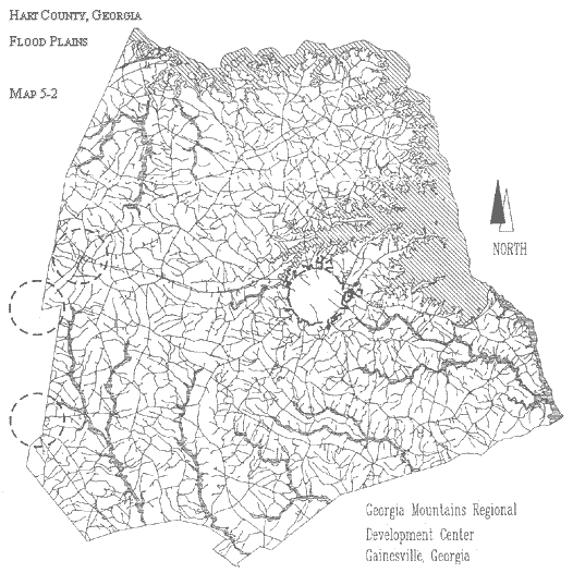
Floodplains north of Bowersville include narrow land areas along Wrights Branch, Pooles, Shoal, and Little Shoal Creeks. Floodplains in the southwestern portion of the county are located along Beaverdam, Little Beaverdam, and Pruitt Creeks. Areas of floodplains in the southern middle section of unincorporated Hart County include corridors along Boyds, Coldwater, Little Coldwater, and Robinson Branch Creeks. Finally, floodplains along Little Cedar and Cedar Creeks can be found in the southeast portion of the county. Floodplains in Hart County are indicated on Map 5-2.
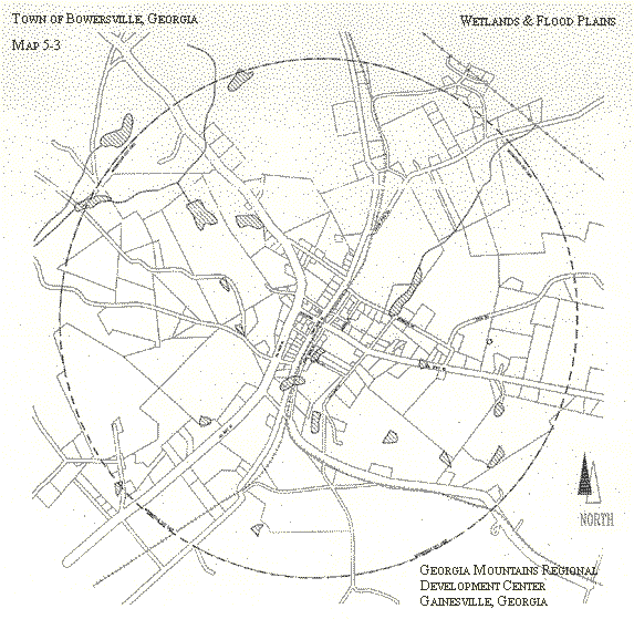
In the Bowersville City limits, three distinct areas of floodplain are found. In northwest Bowersville, land area along Double Branch Creek, bisected by S.R. 17, is prone to flooding. A strip of floodplain is located along the South Fork Double Branch Creek in southwestern Bowersville. Finally, a floodplain runs approximately twothirds the length of the city along Shoal Creek in the eastern half of Bowersville. This flood plain extends from the city limits just south of Adams Town Road to a point south of S.R. 51.
Floodplains in Bowersville are displayed on Map 5-3.
Insert Map 5-2, Hart County Flood Plains
Insert Map 5-3, Flood Plains, Town of Bowersville
Neither Hart County nor Bowersville is currently participating in the National Flood Insurance Program, but this has been included in local work programs.
Concern regarding the quality of public water supplies prompted the state to develop land management measures to protect water sources.
Human activities on water supply watersheds often disrupt natural processes that help maintain water quality. Frequently human activities involve clearing of vegetation, soil disturbance, alteration of floodplains, or some combination of these impacts. Loss of vegetation can increase the rate at which stormwater runs across the ground surface. Rapid runoff increases the amount of pollution in transport and also increases the ability of water to dislodge additional contaminants. In addition to moderating runoff rate undisturbed vegetation also traps sediment and other contaminants. Undisturbed soils and vegetation can encourage movement of water into the soil (infiltration). Water that infiltrates into the ground, rather than running off across the soil surface, comes in contact with chemical and biological processes that hold and break down pollutants. Finally, as well as disrupting these natural processes that control water quality impacts, land disturbances and development create sources of water quality contaminants.
If human activities involve paving of parking areas and roads, or construction of buildings, water quantity as well as water quality can be affected. Paved or impervious surfaces decrease infiltration of water into the soil and cause precipitation to run off more rapidly. The net result is that after storms water quickly moves out of the drainage basin and does not contribute to stream baseflow. The supply of raw water for municipal systems can become less reliable. In addition, as described above, the increased rate of runoff increases movement of contaminants into streams and lakes.
Source:Watershed Protection: A Guidebook for Georgia, University of Georgia, 1988, pp. 4-5.
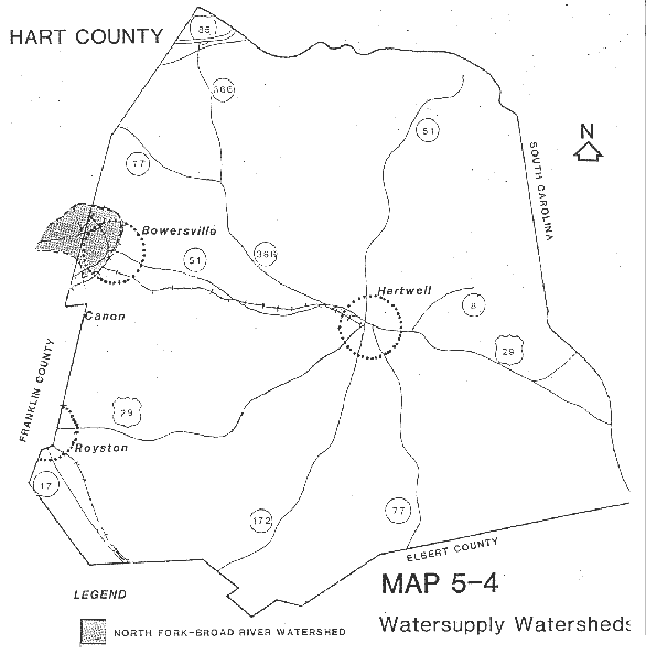
The Georgia Department of Natural Resources has developed standards for the protection of public water supply watersheds. Different criteria apply to large and small water-supply watersheds. Large watersheds are those 100 square miles or more in size, while small water-supply watersheds encompass less than 100 square miles. The City of Hartwell utilizes water from an intake on Lake Hartwell. Public water supply intakes on Lake Hartwell are exempt from these standards because it is a reservoir owned/operated by the U.S. Army Corp of Engineers. Although there are no other public water intakes located in the county, the watershed from a community in Franklin County extends into Hart County. Therefore, portions of Hart County are subject to watershed protection requirements.
The City of Royston, located in Franklin County, has a water intake located in the North Fork Broad River Watershed. The Watershed extends into Hart County as indicated on Map 5-4. Affected areas include portions of unincorporated Hart County and Bowersville. The North Fork Broad River Watershed is a large watershed with a drainage area of 139 square miles.
INSERT MAP 5-4 North Fork, Broad River Water Supply Watershed
The Watershed Protection Plan for the water-supply watersheds in Hart County and Bowersville is presented below.
1. Applicability: This plan shall apply to all properties located within the North Fork Broad River water supply watershed, as generally indicated on Map 5-4.
2. Prohibited Uses.
2.1.Hazardous waste treatment and disposal facilities.
2.2.New sanitary landfills, unless provided with synthetic liners and leachate collection systems.
2.3.Hazardous materials handling facilities, unless operations are performed on impermeable surfaces having spill and leak collection systems prescribed by the Georgia Department of Natural Resources.
3. Uses Exempt From Stream Corridor Buffer and Setback Provisions.
3.1. Existing Uses.
Any land use within the North Fork Broad River water supply watershed existing prior to the adoption of regulations by affected municipalities implementing this plan is exempt.
3.2. Agriculture and Forestry.
Agricultural and forestry uses are exempt, provided such activities are consistent with best management practices established by the Georgia Forestry Commission or the Georgia Department of Agriculture, and provided such activities shall not impair the quality of the drinking water stream.
3.3. Mining.
Mining activities are exempt, if permitted by the Georgia Department of Natural Resources pursuant to the Georgia Surface Mining Act of 1968, as amended.
Public or private water or sewer piping systems, water or sewer pumping stations, electric power lines, fuel pipelines, telephone lines, roads, driveways, bridges, river/lake access facilities, storm water systems, railroads and other similar utilities and road crossings are exempt, if they cannot feasibly be located outside stream corridor buffer and setback areas, subject to the following conditions:
1)The utilities shall be located as far from the stream bank as reasonably possible.
2)The installation and maintenance of the utilities shall be such to protect the integrity of the buffer and setback areas as best as reasonably possible.
3)The utilities shall not impair the quality of the drinking water stream. Implementation of this watershed protection plan is proposed through regulations to be adopted by the participating local governments in 1996 (see the work programs).
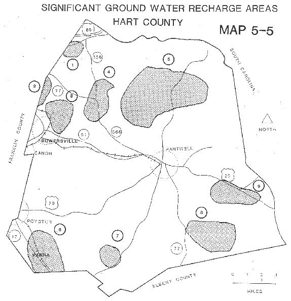
The minimum planning standards for local plans require that local governments address protection of significant groundwater recharge areas. A recharge area is any portion of the earth's surface where water infiltrates into the ground to replenish an aquifer. The Georgia Department of Natural Resources and the United States Geologic Survey have identified and mapped "significant" groundwater recharge areas and promulgated standards for their protection based on their level of pollution susceptibility. Significant recharge areas are identified based generally on outcrop area, lithology soil type and thickness, slope, density of lithologic contacts, geologic structure, the presence of Karst, and potentiometric surfaces.
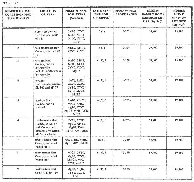
There are nine significant groundwater recharge areas in Hart County. All recharge areas in Hart County are in low pollution susceptibility areas. Map 5-5 indicates the approximate location of the recharge areas. All except one recharge area are located entirely in unincorporated portions of the county; one recharge area falls in the northeast portion of Bowersville. Protection measures identified by the Department of Natural Resources are based on pollution susceptibility, type of soils, and slope. The Comprehensive Plan supports the protection of these areas according to the stated criteria. The plan calls for Hart County and Bowersville to adopt, implement, and enforce ordinances for recharge area protection at least as stringent as the standards developed by the Department of Natural Resources. Protection criteria applicable in the Hart County area are described briefly in Figure 5-1.
| a.The Department of Natural Resources (DNR) shall not issue any permits for new sanitary landfills not having synthetic liners and leachate collection systems b.DNR shall not issue any new permits for the land disposal of hazardous wastes. c.DNR shall require all new facilities permitted or to be permitted to treat, store, or dispose of hazardous waste to perform such operations on an impermeable pad having a spill and leak collection system. d.New above-ground chemical or petroleum storage tanks, having a minimum volume of 660 gallons, shall have secondary containment for 110% of the volume of such tanks or 110% of the volume of the largest tank in a cluster of tanks. Such tanks used for agricultural purposes are exempt, provided they comply with all Federal requirements. e.New agricultural waste impoundment sites shall be lined if they are within a low pollution susceptibility area and exceed 50 acre-feet. f.New homes serviced by septic tank/drain field systems shall be on lots having the following minimum size limitations as identified on Table MT-1 of the Department of Human Resources' Manual for On-Site Sewage Management Systems. g.New mobile home parks served by septic tank/drain field systems shall have lots or spaces having the following size limitation as identified on Table MT-2 of the Department of Human Resources' Manual for On-Site Sewage Management Systems. h.If a local government requires a larger lot size than that required by (f) above for homes or by (g) above for mobile homes, the larger lot size shall be used. i.Local governments at their option may exempt from the requirement of (f) or (g) any lot of record on the date of their adoption of these lot size standards. j.No construction may proceed on a building or mobile home to be served by a septic tank unless the county health department first approves the proposed septic tank installation as meeting the requirements of the Department of Human Resources Manual and (f), (g), (h), and (i) above. l.New facilities which handle hazardous materials, of types and in amounts determined by DNR, shall perform their operations on impermeable surfaces having spill and leak collection systems, as prescribed by DNR. |
An analysis of how the protection criteria apply to minimum lot sizes for homes utilizing septic systems in the nine groundwater recharge areas in Hart County and Bowersville is provided in Table 5-5.
SIGNIFICANT GROUNDWATER RECHARGE AREAS: HART COUNTY AND BOWERSVILLE
1.The Department of Human Resources "Soil Grouping for Use with Minimum Lot Size Table."
2.100% of DHR minimum lot sizes based on "Part Five" standards, where served by on site septic tank systems.3.In mobile home parks. Foot note number 2 also applies.4.Due to variety of soils and frequency of class III soils (unsuitable for septic tank), site specific soil tests are necessary.
State defined standards indicate that rivers flowing continuously throughout the year with an average
annual flow of at least 400 cubic feet per second are subject to provisions for river corridor protection. There are no rivers to be protected in Hart County.
There are no endangered plants in Hart County identified by the Georgia Department of Natural Resources. However, GA DNR has identified "Georgia Plume" (Elliottia Ralemosa) to be a threatened plant species. Several types of wildlife and fish are found in the Hart County area.
Bobwhites, mourning doves, rabbits, squirrels, and non-game birds of many kinds are common throughout the county. Deer and wild turkey require extensive areas of well-watered woodland, such as the area surrounding the Hartwell Reservoir. The long, narrow bottom lands along the streams are well suited to wild ducks and beavers. The Hartwell Reservoir and farm ponds provide excellent fishing. ... The principal game fish in the farm ponds and streams are bass, bluegill, and channel catfish.(Soil Conservation Service, 1963 pp 24-25) Bream, Largemouth Bass, Striped Bass, Hybrid Bass, Crappie Bass and Walleye are fish commonly found in Lake Hartwell. Both the Hybrid Bass and the Walleye are not native to the area and are stocked by the South Carolina Wildlife and Marine Resources Department and the Georgia Department of Natural Resources.
The goal of the Wildlife Management Program operated by the U.S. Army Corps of Engineers is to ensure a variety of habitats suitable for a variety of wildlife. Major efforts include a forest management program, the location of nesting boxes for birds and mammals, and planting of food plots. Community education programs have been initiated by the local Soil Conservation Service Office. Other groups including Ducks Unlimited and 4-H are actively educating the community on awareness and protection of sensitive plant and animal habitat as well as threatened and protected species. Future land use strategies will need to pay attention to this issue as Hart County develops, especially areas in the vicinity of Lake Hartwell. Protected wildlife which may be found in the Hart County area include the Red-cockaded woodpecker (Picoides borealis) which are found primarily in older pine forests and the Southern Bald Eagle (Haliaeetus loucocephalus) which hunt in wetland areas and roost in undisturbed lakeshore areas with large trees.
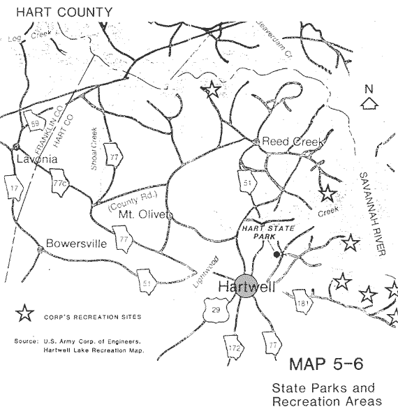
Lake Hartwell, controlled by the Corps of Engineers, is comprised of 55,000 acres of water. The 17,000 acres of water and 215 miles of shoreline which are contained in Hart County provide numerous recreational opportunities. Three recreation areas operated by the Corps of Engineers are located on the lake in Hart County. All have boat ramps, picnic shelters, and playgrounds. One site has a beach. There are nine public access points to the lake, in addition to access provided at full recreation areas and state park facilities. Five campgrounds operated by the Corps are located in Hart County. There are also two marinas lessee operated in Hart County. Three boat access points are operated by the County. The Hartwell Lake Natural Resources Management Center (and Visitor Center) is located at the Hartwell Dam, seven miles east of Hartwell off U.S. 29. Tours of the dam are also available. Hart State Park, located 1.4 miles north of Hartwell off U.S. 29, offers a variety of facilities and activities.
The park, located at the edge of Lake Hartwell, has camping sites, cottages, picnic sites, and a beach. In addition to a boat ramp and dock, fishing boat rentals are available at the park. The Hart County Wildlife Management Area is a 1,000 acre state-owned preserve located in the southeast portion of the county, just north of SR 77. The area is managed for small game and non-game animal species. In addition, limited planting of seed-bearing type plants are made. This state-owned property is popular for hunting. Horseback riding and primitive camping are also allowed in the area. Map 5-6 indicates the location of Hart State Park, as well as Corps of Engineers' recreation sites in Georgia on Lake Hartwell.
Other recreational areas in close to Hart County include Tugaloo and Victoria Bryant State Parks in Franklin County and Traveler's Rest State Park in Stephens County. Watson Mill Bridge State Park and Bobby Brown State Park in Elbert County are also quite accessible from the southern portion of Hart County. A number of Corps of Engineers and South Carolina state facilities are found on the South Carolina side of Lake Hartwell.
As observed numerous parks and recreation areas exist in Hart County. These sites should adequately serve Hart County in the future to the year 2015. Most of these sites are managed by the Corp or Georgia DNR. Additional local measures should be developed to insure the preservation and protection of these facilities.
An inventory of scenic views and sites was taken during the land use inventory prepared in the summer of 1991. Such areas are indicated on the Existing Land Use Map. In general, these scenic views consisted of wide expanses of rolling farmlands. The comprehensive plan supports the preservation of these areas whenever possible, but no specific measures are called for in the plan to preserve these views.
SOURCES CONSULTED: