CHAPTER SIX: HISTORIC RESOURCES
Historic resources include structures and sites, rural resources, archaeological and cultural sites, and the historic environment in which they exist. They serve as visual reminders of Hart County's past, providing a link to its heritage and a better understanding of the people and events which shaped the patterns of development. Preservation of these resources makes it possible for them to continue to play an integral, vital role in the community. Because historic resources are irreplaceable, they should be protected from deterioration and the intrusion of incompatible uses. Preservation can provide Bowersville and Hart County with substantial savings in the cost of infrastructure through the reuse of facilities and utilities and is often less expensive than demolition and new construction. The preservation and the reuse of historic structures can also attract tourism and promotes a quality of life that industry, new business, and residents find attractive in communities.
The area which is now Hart County was part of the Cherokee Nation before white settlement in the mid 1700s. Little is known about the appearance of this area during Cherokee habitation, but it is assumed that it was dominated by the natural landscape. The Indians relinquished their lands to the state through various treaties and, in turn, the state gave these lands, through a land lottery system, to veterans of the Revolutionary War. The Treaty of 1773 and the Treaty of 1783 provided the lands which formed Franklin County in 1784 and Elbert County in 1790.
Portions of these two counties were used to create Hart County in 1853. Following these treaties and the Revolutionary War, this territory was opened for colonization. Settlers, primarily from Virginia, North Carolina, and South Carolina of English, Scottish, Irish, and Welsh descent, moved into the area, obtained title to the land and began clearing the land for homesites and cultivation, in many instances with the help of their slaves. The first settlements were made adjacent to major waterways, the Savannah and Tugaloo Rivers and smaller creeks, to take advantage of the rich bottomland, the most suitable area for farming.
These settlers built substantial homes among their plantation holdings and some of these 1Adapted from Jaeger, Dale and Sybil Bowers, "National Register of Historic Places, City of Hartwell Multiple Resource Nomination," Georgia Mountains Area Planning and Development Commission, 1985.
Structures survive into the present in remote sections of the county. The less desirable back country was thinly settled and where more modest residences were built. All of these early structures were undoubtedly frame and log which utilized the available materials. According to Historical Investigations of the Richard B. Russell Multiple Resources Area, the disposal of surplus farm products became a problem as the population increased. "To minimize the difficulties and expense arising from the primitive transportation system (pole boats on the Savannah River and wagons to markets in Augusta, Athens, Atlanta, and Savannah, Georgia and Charleston, South Carolina), farmers experimented with lightweight staples - tobacco, hemp, and flax. Tobacco became the main staple crop in 1799, but due to its inferior grade it was quickly abandoned in the early 1800s. Following a diversified farm economy which produced corn, wheat, and grain for cattle, sheep and hogs, cotton began to be grown reaching a high point for the antebellum period in 1850."
On December 7, 1853, Hart County, named for Revolutionary War heroine, Nancy Hart, was created by Act of the Legislature. This Act provided for the election of five Justices of the Inferior Court who were instructed to "select and locate a site for public buildings in said new county, to purchase a tract of land for location of the county site, to divide same into lots and sell each at public sale for the benefit of said new county. . ." A local controversy ensued over the location of the county seat town. One group favored the central point of the county identified through the survey, while another group wanted an area known as "The Center of the World," a former Cherokee Indian assembly ground. The group wanting the county seat at "The Center of the World" filed a quo warranto proceedings against the Justices of the Inferior Court and hired T.R.R. Cobb, an attorney from Athens to represent them. The Judges hired Howell Cobb, brother of T.R.R. Cobb also of Athens, as their lawyer and after a legal battle the question was decided in favor of the present location. In May 1854 land was purchased by the Judges for the establishment of the county seat of Hart County. The first county courthouse was a two-story frame building located on Lot 1 on the northeastern side of the square in Hartwell. It was the first structure built in the new town. A two-story frame jail was built on Lot 6 and was replaced by the structure now used as the District Attorney's office in the 1890s. In 1856 a new two-story brick courthouse was constructed to replace the original. This courthouse was destroyed by fire in 1900 and was replaced in 1901 with a two-story Neoclassical style building designed by Atlanta architect J. W. Golucke. Unfortunately, this courthouse was lost to fire as well in the 1960s and was replaced by the current one-story courthouse. As in many counties of northeast Georgia, farming was the primary way of life for most Hart County residents. This is reflected in existing historic resources such as homesteads and crossroads communities found throughout the county. Early in Hart County's history agricultural activities mostly consisted of subsistence farming. These crops included corn, oats, wheat, tobacco, vegetables, and some fruits. Livestock was also raised. Eventually, cotton became the major cash crop. Developments in agricultural practices such as the "introduction and popularization of fertilizers, the solution of labor problems through a share crop arrangement, and the solution of credit problems through a crop lien system resulted in a boom of cotton and cotton-related businesses." Cotton's popularity in Hart County remained even after the coming of the boll weevil in the 1920s. Cotton continued to be a significant part of the local agricultural economy up until 1955, and some cotton gins were in operation through the 1960s.
As mentioned above, the most popular method of transporting crops during the early to mid 1800s was by pole boat on the Tugaloo or Savannah Rivers. Roads were also used such as the Red Hollow Road which ran through Hart County from Toccoa to Augusta. The railroad arrived in Hart County in 1879, although it had been in the works since before the Civil War. The Hartwell Railroad was a spur running from Hartwell to Bowersville. From Bowersville it joined with the Elberton Air Line Railroad which connected with Atlanta, Washington, and New York via Toccoa, Georgia. The railroad made regional and national markets more accessible to Hart County and its communities. Later, U.S. Highway 29 would become a major transportation route for both trade and tourism. The highway was known as the "Main Street of the South" after it was paved in 1933 linking the North with Florida. A few commercial businesses, such as gas stations and country stores, remain along this historic transportation corridor.
The history of the educational system in Hart County closely parallels those in surrounding counties.
Prior to the establishment of the Hart County Board of Education in 1871, private schools, or academies, provided education to the county's children. However, the parents of many children were unable to pay the tuition and board. In 1858 a Poor School Fund was established for this purpose. Following the organization of the county educational system in 1871, both white and black children were given the opportunity for education. In the 1920s, the educational system was consolidated, which led to the creation of several more schools throughout the county. The only high school available in the county was Hartwell High School. In the 1950s, the City and County schools consolidated and by 1970-1 were desegregated. Prior to 1920, black children were educated in schools provided by area churches. Many black children only received an elementary education, however some received scholarships to continue their education at the Savannah River Academy in Hartwell. The Hart County Training School was established in the late 1920s and early 1930s on Richardson Street in the Rome Street community in Hartwell for the continued education of black students. Following the integration of Hart County schools in 1970, the Hart County Training School was used as the Hart County Junior High School. Some black schools that existed in Hart County included: Flat Rock, Sander's Grove, Shiloh, Sardis, New Light, Harmony Grove, Teasley's Grove, St. James, Brown's Grove, Vanna, Mountain View, and New Hope.
Schools in Hart County were oftentimes located in crossroads communities which typically included a church and sometimes a general store, mill, or cotton gin and served the commercial and social needs of the surrounding farms and homesteads. Some of these crossroad communities include Shoal Creek, Reed Creek, Mt. Olivet, Air Line, Goldmine, Bio, Flat Rock, and Sardis. Only the church and school remain in many of these communities. Some other communities, both existing and non-extant, include: Parkertown, King's Bench, Maretts, Nuberg, and Montevideo. Until recently, the town of Vanna had been one of the few incorporated communities in Hart County. The village was originally known as "Friendship," but the post office name was changed to "Vanna," after Miss Savannah Ballenger, by Ezra Bowers who was a mail agent on the Elberton Air Line Railroad. The town of Vanna was incorporated in 1912 and had a city limit with a one-half mile radius, which was centered on the depot. The first mayor of Vanna was D.M. Denny, depot agent and owner of a general merchandise store. Some of the businesses and services once available in Vanna included a depot, school, ice house, gin, blacksmith shop, barber shop/soda fountain, garage, and various stores and warehouses. Few of these exist today. During the 1920s, the cotton industry began to slow down as a result of the spread of the boll weevil, a severe drought in 1925, and a downturn in the competitive cotton markets throughout the nation, which signaled an end to the cotton industry in Hart County. In 1929, the stock market crashed, which resulted in the Depression experienced throughout the country in the 1930s.
As a result of the Depression, several recovery programs were initiated by the government. The government provided such New Deal programs as the Seed Loan Program, which helped farmers, and the Works Progress Administration (WPA), which aided unemployed workers. In Hart County, a few schools were constructed by the WPA including the Mt. Olivet Gym and the Air Line School. WPA also helped construct Hartwell Elementary Gym. During and following World War II, the economy in Hart County and its communities began to diversify. Although industry became more important in and around the outskirts of Hartwell, agriculture was still an important factor in Hart County. However, the number of farms decreased from 2,593 farms in 1930 to 2,413 farms in 1950 and down to 507 farms in 1987. Although farm acreage increased slightly from 134,863 in 1930 to 144,495 in 1950, farm acreage dramatically decreased to 62,286 acres in 1987. Part of the significant drop in agricultural land may be attributed to the development of Lake Hartwell. In 1950 Congress authorized the construction of Hartwell Dam. By 1961, Lake Hartwell was completed and full and is now maintained at approximately a mean sea level of 660 feet.
The original land encompassing the Town of Bowersville was once the property of William F. Bowers. His father, Job Bowers, had settled in the area, then part of Franklin County, during the early part of the 19th century near the headwaters of South Beaverdam Creek. He was a farmer, merchant, gunsmith, and blacksmith and also held the positions of county surveyor of Franklin County and Justice of the Peace in Hart County. A post office was established in his home and he served as post master until the Civil War. His place, which became known as "Bowersville Post Office," appears on Georgia maps as early as 1834. Job's eldest son, William F. Bowers (1825 - 1905), was instrumental in the establishment of Bowersville. 2 Adapted from Town of Bowersville Historic District National Register Information Form, prepared by Dale Jaeger as part of a project for the Georgia Mountains Area Planning and Development Commission, Gainesville, Georgia, 1984.
According to the History of Hart County, the town was laid out in May 1878 on land belonging to William F. Bowers. W.F. Bowers, described as "the most noted of the Bowers family," was a farmer, merchant, a Baptist minister, state senator, and publisher. The town plan evolved around the railroad. In 1879, the Elberton Air Line Railroad had been completed to Bowersville. A depot was built, which remained the only depot in Hart County until completion of the line from Hartwell to Bowersville almost a year later. The original Bowersville Post Office was moved to the new town center and the former name reused. In 1881, the railroad was given "all land within 60 feet in width on each side of the track," which ran through the center of the town.
The first lot sales were made to the town's earliest merchants. Names of several early merchants are still reflected in today's street names. Some of these early businessmen included Edward Schaefer, who established a large cotton and fertilizer business; S.T. Fleming, who built a general store; and Jim Watson, who operated a confectionery. In 1879, E.B. Benson purchased three lots for use as a general merchandise store and guano warehouse. The warehouse was located in the railroad right-of-way and was the only exception mentioned in the 1881 deed between W.F. Bowers and the railroad. It is interesting to note that improvements to W.F. Bowers' land by E.B. Benson and the railroad were made prior to the purchases. W.F. Bowers evidently planned to be instrumental in the town's development. All lots sold by Bowers included a clause that "no intoxicating liquors shall ever be sold, given away, or otherwise disposed of on said property." Failure to observe the clause meant that the land reverted to Bowers, his heirs, executors, or administrators.
In 1883, the developing town was chartered. The corporate limits were extended one-half mile in every direction from the depot. A Bowersville column in the Hartwell Sun reported that year a school house was under construction. Land for the school, to be known as the Bowersville Academy, had been given for $10 by W.F. Bowers in December 1882. Bowersville had a hotel by 1884 and was reported as thriving in 1887 and at the present rate of development was predicted to "excel her sister railroad towns." On October 20, 1888, over one-half the business district was lost to fire. The fire, which began in Schaefer's warehouse, destroyed the T.H. McLane residence, J.A. Reece store, S.T. Fleming store and residence, E.W. Roberts' new hotel, J.W. Holbrook residence, and 372 bales of cotton. The town appears to have recovered quickly. A news account two months after the fire stated that eight new buildings were going up. In June 1889, a delegation from Hartwell visited the town. Bowersville was described as having "schools and churches after the modern style, blessed with excellent railroad facilities, surrounded by good territory, and peopled with clever farmers." The list of businesses included two livery stables, three general merchandise stores, a jewelry store, cotton buyer, and the new Roberts Hotel. The school at Bowersville continued to thrive with enrollment at 139 by 1889. Bowersville was called the "educational and railroad center on the Elberton Air Line Railroad." There were also three churches (Presbyterian, Methodist, and Baptist) at Bowersville by 1889. The town continued to prosper in the late 19th and early 20th centuries. The population increased from 275 in 1890, 294 in 1900, to 398 in 1910. The town limits were expanded to one mile in 1908. A public school system for the town was established in 1911.
According to long-time residents, the passenger depot was located in the center of the town in front of the existing two-story brick building. There was a less elaborate freight depot in the railroad right-of-way to the north. The two-story brick structure was built by S.T. Fleming for his general merchandise business. The northern end of the building was constructed after the fire in 1889 and the southern end, which housed a separate business, after 1900. The upstairs of the structure was used as a Masonic Lodge. At one time there was a frame doctor's office on the corner beside S.T. Fleming's building, but around 1907 Bunyan Bowers built the existing one-story brick building (connected to the Fleming Building) as a hardware store. It also served as the post office while Bunyan Bowers was post master. The later store in Fleming's building burned in 1916, but only the interior was damaged.
The Bowersville Hotel stood to the north of the Fleming Building. It was a two-story frame structure with a wide veranda at each level. It had been built by Roberts after the fire and was owned by Weaver in the early 1900s. The hotel was a favorite stop for "drummers," or salesmen, and the traveling public. The brick and frame warehouses in the railroad right-of-way were built by the Farmers Union with Bunyan and Ansley making the brick and carrying out the construction. The frame structure was called the "hull house" since hulls from the cotton seeds were stored inside. In 1917 a three-story high frame mill was built in the right-ofway north of the hull house, but was demolished in 1930. The existing commercial block was built in different stages. S.B. Cannon built the structure at the north in 1908 as a general merchandise store. The bank was built on the southern end about the same time. Roe Cannon also lived in the house next door and was said to have been built closer to the street for use as a boarding house and later moved. A daughter of Cannon, Miss Lil Cannon, was responsible for establishing the pecan grove around 1920. Other residences still existing today housed Dr. Sanders, a local physician; Horace Cheek, operator of the flour mill; Hubert Cheek, general merchandiser; John Doyle and Sam Verner, both bankers; Bunyan Bowers, a farmer; and John A. Johnson, post master. Development in Bowersville slowed with the decline in the cotton economy, caused by the boll weevil and the drought of 1925. The population high in 1910 of 398 decreased to 390 by 1920 and 271 by 1930. The school system was abolished in 1924. Few physical changes have occurred in the town center since 1930 with the exception of losing the hotel to fire and the depots to demolition. 6.2. Historic Properties.
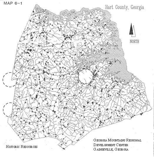
Hart County's historic properties have been categorized according to property type to help identify them more clearly. These categories include: residential resources, commercial resources, institutional resources, industrial resources, rural resources, and historic, archaeological and cultural resources (see Map 6-1). It is important to emphasize that the exclusion of some historic resources from the following sections does not necessarily indicate that they are not significant or worthy of preservation.
The greatest majority of historic building stock in Hart County are residential structures. The historic residential buildings are primarily of simple, common (vernacular) designs with the majority dating from the late 19th century to 1940. There are some antebellum houses remaining, however, many of these have been altered over the years, or have been abandoned and are suffering from demolition by neglect. Many of the vernacular historic structures in Hart County exhibit restrained stylistic elements, but most lack a great deal of ornamentation. Those houses that do possess stylistic elements exhibit primarily Greek Revival (entranceways, massing), Victorian-era (porch posts, trim, roof lines), or Craftsman (brackets, porch piers/posts) stylistic features. The infrequency of high style structures may be attributed to the rural agricultural nature of Hart County. Examples of structures exhibiting high style influences include the Patterson-Turner House on State Route, the Teasley-Norman-Bosley House off State Route 77 near Nuberg, the Thornton Homeplace off Flat Rock Road near the Elbert County line, and the McMullan House near New Prospect Church. Styles and types of residential structures in Hart County remain fairly consistent with its rural heritage, exhibiting local craftsmanship and the utilization of local materials. Almost all of the historic residential structures are wood frame houses and most have brick chimneys, although several houses with stone chimneys remain.
Log construction still exists in Hart County, however, many of these structures have been added onto or covered by clapboards (a common practice), abandoned, moved, or are suffering from demolition by neglect. An example of log house construction may be seen near the intersection of Shoal Creek Road and Kings Road off Highway 77 in northern Hart County. This one story structure has been neglected for several years and should be repaired soon, or it will be lost. Another example of log house construction is the Mewborn-Phillips House in southern Hart County off Highway 172. This house is an excellent example of log structures which have been added onto and sided with clapboard siding. The Mewborn-Phillips property has recently been restored and is being nominated to the National Register of Historic Places by the owner. Another example of a log house which has been added onto is the Higgenbotham-Norman House in the Nuberg community.
This evolution was a typical historical treatment of log houses and should also be respected and preserved. The most commonly represented house types in Hart County are central halls, hall and parlors, gabled ells, pyramidal cottages, Queen Anne cottages, and bungalows. Central hall and hall and parlor types both tend to be two rooms wide with differences being in their floor plan. The central hall consists of two rooms separated by a hallway and is usually side gabled. The main body of the house is one room deep and frequently has one or two exterior chimneys. The McMullan House and the Partain-Senkbeil House, both in the New Prospect Community, are excellent examples of this type. The hall and parlor type also tends to be side gabled, one room deep, and consists of two rooms unequal in size with the entrance leading into the larger of the two rooms. Both of these types can be found intact, or with various additions either to the front, rear, or side of the structure.
The gabled ell house type is characterized by a T- or L-shaped plan and is typically gabled with an entry into the recessed wing parallel with the facade. Interior chimneys are most common. The pyramidal cottage was a simple, common house form of the early 20th century. It is characterized by a square main mass with four principal rooms and no hallway. The steeply pitched pyramid-shaped roof is the most recognizable aspect of this house type.
Queen Anne cottages, not to be confused with highly ornamented Queen Anne high styles, have a square main mass with projecting gables on the front and side. The rooms are arranged asymmetrically and the roof is either pyramidal or hipped. The bungalow house type was also found in Hart County. It is characterized by its overall rectangular shape and irregular floor plan with four possible roof forms: side gable, front gable, hip, and cross gable. Other characteristics include an integral porch, low pitched roof, and wide roof overhangs. Two common historic residential house forms were found in Hart County. One form includes a two-story, side-gabled hall and parlor or central hall plan with end chimneys and two wall dormers, or gablets, on the front facade. Another type common to Hart County is a Queen Anne cottage with two front gables and, frequently, a small gable dormer and a two- or three-sided porch. Two examples are the Bailey-Wilson-Jenkins House near Maretts and the Gurley-Lawson House on Lou Gurley Road off State Route 77.
Several properties were found that would qualify as eligible for listing in the National Register of Historic Places, however, few potentially eligible districts were found. Typically, historic districts contain a number of historic structures which relate to one another historically, geographically, and/or architecturally. Historic districts include landmark quality structures as well as less significant structures. Due to Hart County's rural nature, the majority of historic resources are spread fairly consistently throughout the county. Many of these resources, however, suffer from demolition by neglect, which occurs when a property is abandoned and then deteriorates or when a property owner allows a structure to go unmaintained until it becomes derelict beyond repair. This results in an otherwise potential district lacking a sense of cohesion. A few exceptions include: part of the community of Vanna; Nuberg; a collection of rural residences and outbuildings located along Mouchet, Reed, and Lankford Roads; the Sharon Church/New Prospect Church community; and the area along Beacon Light Road above Maretts. These districts have the potential for listing in the National Register and possible tax incentives for substantial rehabilitation as a result of listing in the National Register. Other potential rural districts may exist and can be pinpointed by a comprehensive survey of the County's historic resources.
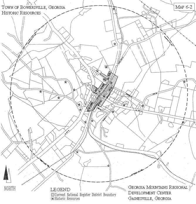
Historic residences in Bowersville are primarily of vernacular design and date from the late 19th century to circa 1925. Constructed of wood, which is used both structurally and decoratively, they are typically modest onestory houses with prominent porches. The most elaborate have Victorian era detailing including gabled ends trimmed with decorative shingles, porches trimmed with turned, chamfered, or classical columns, sawnwork brackets and spindle friezes, and, in one instance, a sunburst design in a porch-roof pediment. The simplest houses, frequently with gable roofs and L- or T-shaped plans, have no detailing except for attic vents placed in gable ends. Many of the historic residential structures in Bowersville have been listed in the National Register of Historic Places since 1985 (Map 6-2). These houses may be eligible for tax incentives for substantial rehabilitation work. Since many historic houses in Bowersville appear to need some maintenance and/or rehabilitation, it is suggested that property owners consider the use of state and federal tax credits.
Few historic commercial buildings remain standing in unincorporated Hart County. Many of the commercial buildings that remain are in poor condition and in danger of being lost to demolition by neglect. Those remaining that are still recognizable as commercial buildings take various forms, but the most common form is a front gabled, wood frame building that is two or three rooms deep. Usually the front entrance is flanked on either side by a window. An example of this can be seen in Vanna in the center of town. A rural example can be seen in the Mt. Harmony Church area near Bailey Road. An unusual example is located at the intersection of State Route 59 and Shirley Road. This old store is sided with molded concrete and has a hipped roof. This commercial building, as well as the old farmstead across from it may be eligible for listing in the National Register. A rare example of a rural brick store is located in Goldmine.
The remaining historic commercial buildings are significant as they are representative of all small Hart County communities, many of which are no longer recognized as such today. The rural and small community commercial buildings are also significant as examples of vernacular commercial building design. Most of the remaining structures date from around the turn of the century to circa 1925.
The historic commercial district in Bowersville on either side of the railroad line on East and West Main Streets illustrates typical building technologies, materials, types, and styles of the period. The one- and two-story brick buildings have intact building facades, which is becoming more rare, and exhibit common commercial architectural features such as corbeled cornices and sign plates. The commercial buildings include a row of four one-story stores with party walls built between 1908 and 1910; a two-story store with an old Masonic Lodge meeting hall on the second floor and an attached one-story store (1889-1907); and two warehouses in the right-of way, one historically used for storing cotton, the other cotton hulls. A unique and attractive feature of the commercial district is the park-like open space which is the railroad right-of-way. The commercial area of Bowersville was listed in 1985 in the National Register as part of the Bowersville Historic District. 6.5. Institutional Resources.
Institutional resources in Hart County include structures such as schools, churches, and government buildings. A few historic schools still exist, although many have been altered or abandoned and are being lost to demolition by neglect. Early in Hart County's history, schools were primarily one room wood frame structures, sometimes associated with a nearby church. Few if any of these types exist, however, two wood frame schools believed to have been constructed around the turn of the century and the early 1900s respectively exist in the Flat Rock Community. The older one has been totally abandoned and is being lost to neglect, but the other is being used as a community building. Many school buildings were constructed in Hart County (typically of brick) in the 1920s and 1930s. An example of one of these is Shoal Creek School.
Historically, the local church in Hart County was very important to communities not only as spiritual centers, but also as a meeting place for an area. Many of these churches started out as simple brush arbors or log structures, but eventually most were of basic clapboard design with rectangular plans. The only example of such a church, which has not been significantly remodeled, is Mt. Harmony Church located in the northern part of the County. There are a few historic churches in Hart County constructed of brick. Two good examples are the Cross Roads Baptist Church completed in 1920, and the Redwine Church, built in 1906. Religious campgrounds also served as both spiritual and social centers for area residents. The Hartwell Campground, located off U.S. 29/S.R. 8 on Elrod Ferry Road, remains as an active campground consisting of a historic arbor and "tents" or crude cottages. Traditionally, worshipers spent a week during the summer at the campground.
Few historic institutional resources remain in Bowersville with the exception of the Bowersville Baptist Church, which was constructed in 1939. The only major changes made to the building since its construction were the addition of the steeple, and a rear addition.
Industrial resources may include historic railroad structures, mills, and factories. Few historic industrial resources were noted in unincorporated Hart County or Bowersville, which may be attributed to its largely agricultural past. At one time, mills and cotton gins were scattered throughout the county and played an important role in the districts or communities where they were located. A few cotton gins and grain mills may still be found such as those located at Maretts and Hickory Crossing. The old mill at Parkertown, though deteriorated, still stands off State Route 77/366, although the water wheel is gone. Parkertown, originally settled in 1832 by Joseph Parker, was once the site of a wool factory, a stone dam, a grist mill, and a flour mill. Little remains of this historic commercial enterprise. The historic Gaines Mill, located south of the Flat Rock Community near the Elbert County line, is still intact except for the wooden water wheel which was replaced by a metal wheel. Historic railroad buildings, including storage/warehouse facilities, can be found in Bowersville and Vanna.
An old depot or railroad storage facility is also located in Air Line.
Rural resources can include numerous aspects of a county or community. These resources include, but are not limited to, barns and outbuildings associated with agricultural activity, open space such as pastures and fields, agricultural landscapes such as pecan groves, abandoned rail beds, covered bridges, and scenic byways. Hart County's history, for the most part, is centered around its rural heritage. Its landscape reflects this heritage and should be preserved as much as possible.
Since Hart County was historically made up of agrarian communities, there are a number of agricultural outbuildings throughout the county. These farm buildings can be found either clustered together or alone in the field of an old farmstead. Unfortunately, many of these buildings are no longer in use and are being lost to demolition by neglect. One such example is the unusual barn located on State Route 77 past Flat Shoals Creek two miles northwest of Hartwell. This barn has a gable on the front facade, which is a unique trait found in Hart County. The property, which includes a Queen Anne cottage farm house, appears to be abandoned and may be lost to neglect if left unmaintained. Another property with excellent examples of agricultural outbuildings is located on Kings Road. One of the barns is of log construction. Two other farms with excellent collections of intact outbuildings are located on Mouchet and Lankford Roads. There are many areas in Hart County exhibiting outstanding scenic views, as well as picturesque countryside, agricultural landscapes, and river corridors. Important agricultural elements in Hart County are the numerous pecan groves. Historically, grafted pecan trees from throughout the county's nurseries were shipped to South Georgia. Some pecan groves can still be seen at the Kay Nursery, in Vanna and Bowersville, and Northeast of Hartwell south of Hart State Park.
With the establishment of the large recreational lake, Lake Hartwell, and the major highway, Interstate 85, Hart County is likely to see continuing residential growth and an increase in the local economy. The potential for negative impacts on existing rural resources is great; thus, proper planning for growth and economic development should be a priority.
A variety of historic, archaeological, and cultural resources exist in Hart County. Among them are the many historic cemeteries associated with churches, communities or individual families. These old cemeteries are excellent sources of historical information and should be protected in accordance with the Georgia Abandoned Cemeteries and Burial Grounds Act of 1991. A few examples of extremely historic cemeteries include: the Old Reed Creek Church Cemetery in which is buried Revolutionary War soldier Moses Ayers; Redwine Church Cemetery; Providence Church Cemetery; family cemeteries, several of which are located in the northern part of the County, such as the Johnson, Poole, Pinson, Crocker, Fleming, Byrum, Mewborn, etc. Cultural sites such as memorials can be found in Hart County and include: the Cherokee "Center of the World" Memorial erected by the Benson Chapter of the D.A.R. in 1923; the Nancy Hart Monument dedicated on November 11, 1931 and erected by the Benson Chapter, D.A.R.; and Hendry's Church Monument.
A formal countywide survey of Hart County's archaeological resources has not been undertaken. Knowledge of such resources consists of information gathered by a variety of means. They range from surveys and investigations of varying scale, such as those conducted by the Corps of Engineers, to reported sightings by individual collectors and professionals. These archaeological sites, most specifically the prehistoric, are susceptible to damage caused by development or collection by non-professionals who do not properly record the site information and location. Archaeological sites need not be prehistoric to be significant. There are a few sites in Hart County that relate to events ranging from the early settlement period to the early 20th century. For instance, remnants of old mills, such as the one at Parkertown or Gaines Mill below Flat Rock Community near Elbert County, provide valuable information on early grist mills and the developmental history of local technology. Since Hart County was at the center of much Native American activity, the archaeological potential in this area is very promising and should be further investigated.
The Tugaloo and Savannah Rivers and various major creeks exhibit a great deal of potential for containing both prehistoric and historic archaeological resources. They are archaeologically and historically sensitive areas and may be irrevocably damaged by insensitive development and despoliation. Resources present in and along other water resources are similarly sensitive to damage and should be protected and guarded against any further damage. Appropriate management should incorporate an archaeological survey of the properties as an initial stage of resource planning. Such an inventory would provide a basis on which to plan development and evaluate research potential for addressing questions about the past.
A loss of historic resources in Hart County was experienced during the construction and subsequent development of Lake Hartwell. Currently, there are many historic resources in Hart County which have remained relatively intact and were found to be evenly dispersed. However, many historic resources have been lost and are being lost to demolition by neglect, which occurs when property is abandoned and deteriorates, or when a property owner allows a structure to go unmaintained until the structure becomes derelict beyond repair. Demolition by neglect is the primary negative impact on historic resources in Bowersville and Hart County, as well as in the community of Vanna. Many of these resources will be lost if not maintained on a regular basis or restored within the next few years.
In Bowersville, most historic resources, including both commercial and residential, are in fair to good condition, but many require cosmetic maintenance and/or extensive repairs. Several historic commercial buildings in Vanna are being lost to neglect. Also, there are many historic residences that have sustained inappropriate remodeling or require extensive repairs. Most of the historic resources in Vanna that are in good to excellent condition are located at the south end of town. The permanent loss of historic and cultural resources would be detrimental to the County. Only by informing the residents of the County of the economic and cultural benefits historic resources provide will the problem of demolition by neglect decrease.
These benefits include an increase in heritage tourism, economic development, and an understanding and appreciation of Hart County's rural past. Two other impacts which may affect historic resources in Hart County are the development of land on or near historic or cultural sites and alterations or remodeling which drastically alters the architectural integrity of historic resources. Although incompatible development on or near historic resources is not yet a significant problem in Hart County, increased development along the Interstate 85 corridor, development adjacent to the lake, as well as the possible construction of a four lane route to I-85 and the proposed by-pass around Hartwell may, in the future, impact those historic resources located along the routes. However, if properly planned, potential development and construction in these areas could directly and indirectly benefit historic and cultural sites by attracting both tourist and business dollars to additional parts of the County not located along the corridor. A preservation and/or heritage tourism plan could incorporate ways in which Hart County may take advantage of their historic and cultural resources for the benefit of the visiting public, thus preserving their resources and generating income.
The following are elements of a potential preservation plan for the Town of Bowersville and Hart County. They are suggested steps to follow to implement preservation in Hart County, but are by no means a complete plan in themselves. Much more extensive research and time would be necessary to produce such a plan. Ideally, the county can pursue all of the following objectives, but it is wise to take one at a time to achieve long-lasting and community supported preservation.
The most recent survey of Hart County's historic resources was undertaken by the Department of Natural Resources in 1976-77. This survey, while good, is not comprehensive. Many important historic resources were not included in the survey as indicated by a recent preliminary, or "windshield," survey which noted almost 300 historic structures. An updated survey would give a more accurate count of the historic resources in the County and more detailed information about the properties. Surveys can be used to identify individual buildings, and districts for possible listing in the National Register or Georgia Register of Historic Places; support local governmental agencies; aid preservation and land-use planning; and promote research of the state's history and architecture. Also, through the public's participation, encouraged by the Office of Historic Preservation, surveys can increase awareness of, and interest in, a community's historic buildings. A Contract for Services survey grant can be applied for through the Office of Historic Preservation in the Department of Natural Resources for funds to conduct a county-wide (including all municipalities) survey.
Once a community or county knows what and where its historic resources are, then it can begin to recognize these resources and bring community attention to their significance. One tool a community can use to achieve this is the National Register of Historic Places. The National Register of Historic Places is the nation's list of historic buildings, structures, sites, objects, and districts worthy of preservation. Although listing in the National Register does not protect properties from alteration or demolition, it serves as a good way to bring recognition of and pride in a community's historic properties. National Register landmarks and districts also serve to pinpoint areas in a community where preservation and local protection can be implemented. Current National Register listings in Hart County include: the Multiple Resource Nomination of Hartwell (1984); Bowersville Historic District (1985); Patterson-Turner House (1990) and several others. Properties in the process of being nominated include the Mewborn-Phillips Property, Gurley-Lawson House, and the Bailey-Wilson-Jenkins House. Some potential National Register nominations include those already mentioned above in previous sections, as well as a property located on County Road 192 off Bartlett Road, the log house and adjacent property on Shoal Creek Road, a recently rehabilitated Queen Anne cottage located on State Route 172 and County Road 60, the Thornton Homeplace, the Caudell House on State Route 172 and Eagle Grove Road, the Teasley-Norman-Bosley House, and the Ayers-Payne House in Reed Creek. The Preservation Planner at the Georgia Mountains Regional Development Center or the State Historic Preservation Office in the Department of Natural Resources should be contacted to assist in the determination of eligibility of the resource(s) and in the preparation of National Register nominations.
Once all of the county's resources have been determined, the community needs to decide which of these resources are most important to preserve, usually those deemed worthy of National Register recognition, and they should be informed of the benefits of preservation including: Historic resources are top tourist destinations. Revitalized buildings and historic districts attract new business and tourists, stimulating retail sales and increasing sales tax revenue. Historic rehabilitation creates new jobs during construction and later in new offices, shops and restaurants. Property values tend to improve in revitalized areas. Investment Tax Credit programs are available for certified rehabilitation. Less energy is required to rehabilitate old buildings than to demolish and replace them with new construction.
In recent years, studies have shown that tourism is playing an increasing role in both the U.S. and Georgia economy. Tourism is the second largest retail industry in the country. The Georgia Tourist Division reported that in 1988 almost 15 million people visited Information Centers statewide and possibly twice that number actually visited Georgia. In 1990, tourism expenditures were $9.7 billion across the state with approximately 188,000 jobs directly supported by the tourism industry. State and local taxes derived from direct tourist expenditures have amounted to $166 million and $180.3 million respectively. A large part of the tourism market involves historic sites as destinations. Hart County should be able to capitalize on the tourism industry because of its many attributes such as its historic sites, its proximity to Lake Hartwell, state and local parks, and its proximity to Interstate 85, a major transportation route. The Hartwell Railroad corridor could also be utilized once again as a tourist draw, if not as a passenger railway, then as a railtrail.
Heritage tourism can play an integral role in Hart County's economic development. The development of a county-wide heritage tourism plan in partnership with the Cities of Bowersville and Hartwell would provide the County with an analysis of tourism potential in the area, a set of objectives, as well as tools and techniques to implement a heritage tourism strategy. Coordination between Hart County, the Hart County Chamber of Commerce, the Cities of Bowersville and Hartwell, Parks and Recreation Departments, and the Hart County Historical Society should be an integral part of any tourism planning process, as well as the marketing and promotion of heritage tourism. An important factor in this process would be increasing the visibility of the Hart County Chamber of Commerce. Finally, coordination with other communities and counties in the Georgia Mountains region should also be considered while developing a heritage tourism plan. In 1989, the National Trust for Historic Preservation initiated a three year program to promote heritage tourism across the country. From this, many case studies and resource materials were developed to assist communities in the development of heritage tourism. The National Trust suggests five principles to follow when considering heritage tourism in your community:
Several funding sources exist for heritage tourism plans and some eligible activities. These sources may include the Office of Historic Preservation's Survey and Planning Grant, the Department of Community Affairs' Local Development Fund, and the Transportation Enhancement funds through the Intermodal Surface Transportation Efficiency Act (ISTEA).
Goals and priorities should be set for the preservation of historic resources in Hart County and the City Bowersville. These goals might include preserving specific rural areas of the county and making the community aware of their importance, protecting the most important historic resources in the county from demolition or demolition-by-neglect, or implementing a heritage education program based on the county's archaeological and architectural resources.
The final step in developing a plan for preservation in the Town of Bowersville and Hart County is to implement the tools and actions needed to achieve the community's goals. These tools or actions may include a survey, National Register designations, a city/county preservation ordinance, financial incentives and community development programs. Information about these programs may be obtained from the Georgia Mountains Regional Preservation Planner or the State Office of Historic Preservation in the Department of Natural Resources.